The Großglockner: An Alpine Road Meant to Be Experienced
You can reduce this road to a toll ticket and a postcard. Neither does it justice. It is one of the few routes you don’t drive-you experience it, in every sense of the word.

 //DRIVE
You can reduce this road to a toll ticket and a postcard. Neither does it justice. It is one of the few routes you don’t drive-you experience it, in every sense of the word.
There are routes you look up in the sat-nav, and there are routes you plan to take. The Großglockner High Alpine Road belongs to the second category. You don’t happen to drive it because it lies on your way. It never lies on your way. You drive it because you want to drive it, and that changes everything-even before you reach the barrier-about how the whole day will feel.
Most passes are a means to an end. They get you from one valley to the next, quickly and without drama. The Großglockner is the opposite. Here the journey is not a transition; it is the destination itself. Anyone who climbs it wants to arrive nowhere except at the top, wants the bends, the altitude, the moment when the tree line falls away beneath you and above you only rock, snow and a very big sky remain. This is no route for hurried people. It is a route for people who set aside a morning for it and never regret the decision.
Construction began in the late 1920s; the road opened on 3 August 1935. Five years to carve a drivable link across the Alpine ridge in a region where the weather can flip in summer as suddenly as April elsewhere and winter rules two-thirds of the year. Picture it: no hydraulic diggers as we know them today, no GPS, no weather forecast worth the name-just hands, explosives, horses and a stubbornness that almost deserves admiration.
What emerged is a road that still ranks among Austria’s highest metalled passes and the only one to cross the Alpine ridge at this point. It was never intended as a dry traffic artery that accidentally turned out scenic. From the start it was designed as an experience, a panoramic route long before the word became a tourism cliché. When you drive it, you’re travelling through a slice of engineering history that never wanted to be merely functional. You feel that in every switchback, in every alignment that clings to the mountainside rather than slicing through it brutally.
Today the route is toll-bound, and for good reason. A high-mountain road above 2,500 metres does not maintain itself. Every winter gnaws at it, every spring begins with clearing, and some snow walls at the roadside still tower man-high in June. The toll here is not a shortcut toll, but the price for preserving something that would long since have crumbled without this upkeep.
This is precisely where it differs from a stretch of motorway. On the motorway you pay to save time. On the Großglockner you pay to lose time-in the best sense. You stop, you get out, you look around. Nobody drives this route to set a record, and anyone who tries has missed the point of the place. The most beautiful way to drive here is the least economical.
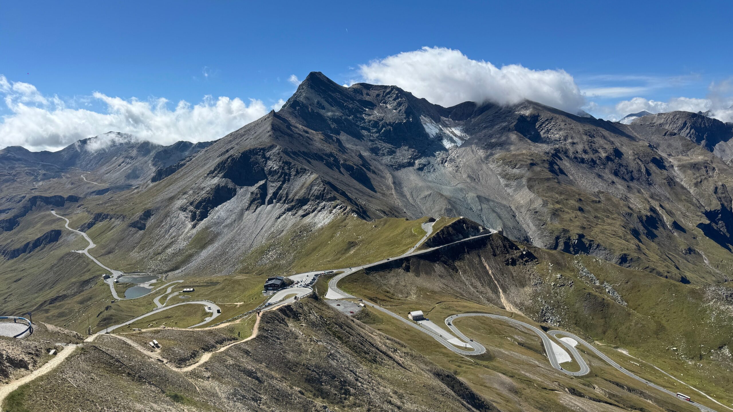
The raw numbers give it a skeleton. The link from Bruck an der Großglocknerstraße to Heiligenblut am Großglockner measures roughly 47.8 kilometres, crossing the watershed once. The operator itself speaks of about 48 kilometres of adventure road and 36 switchbacks-statistics that translate at the wheel into something decidedly physical. Thirty-six times you steer hard into the bend, thirty-six times the mountain comes at you from the other side, and sooner or later you find a rhythm that grips you for the rest of the day.
A drive over the Großglockner is a ritual, and rituals follow a fixed sequence. It begins with the season, because unlike a normal federal highway, this road isn’t available year-round. The operator opens it roughly from early May to early November; the rest of the year belongs to the snow. Already that makes every trip something limited. You can’t just decide to head up in February. You have to wait until the season reopens, and that waiting is part of the allure.
Then there’s the start in the valley. Down below it’s often warm, summery, harmless. You set off in T-shirt weather, knowing it won’t stay that way. With every meter gained, the air changes. It grows thinner, clearer, cooler. The vegetation shifts, from forest to alpine meadow to scree. And at some point, at the Hochtor at 2,504 meters-the highest drivable point on the route-you stand in a world that has nothing to do with the warm valley you left behind. Up here, snow can linger even in high summer, and it’s perfectly normal to shiver in mid-July.
This road doesn’t want to be conquered. It wants to be driven, slowly enough to understand it.
The Hochtor is the true apex of the journey, in the literal sense. Here runs the Alpine main ridge, the great watershed. You’ve climbed up on the Salzburg side; from here you roll down again on the Carinthian side. It’s a transition that feels different from a normal pass crossing because it’s so unmistakable. Before: one valley, one federal state, one light. After: the other. Anyone with a feel for such lines senses the shift not just on the map.
On the Carinthian side, the view opens up-the one many come for. The Großglockner itself, Austria’s highest peak, doesn’t appear here as a distant jagged silhouette on the horizon but stands present and close, with its glacier in front. It’s the moment when the route delivers on its promise. You haven’t just driven over any old pass. You’ve driven to where the land reaches its highest point, and it shows you its best side in return.
This arrival is the reward for the elevation gained earlier. The glacier, so close it seems within reach, provides a natural endpoint-no artificial lookout tower, no souvenir stand needed to heighten the effect. The mountain simply stands there, and that’s exactly what makes it greater than any staging.

What ultimately defines the drive is the sum of all these moments, not a single highlight. It’s putting on your jacket at the summit although you were sweating below. It’s the scent of cold mountain air mingling with warm asphalt in the same curve. It’s the hand on the wheel that, after the twentieth bend, knows how much lock the next one needs before your mind has decided. None of this appears in any spec sheet, and no drone footage can replace it. You have to drive it.
It would be easy to romanticize the Großglockner High Alpine Road. The myth is large, the images are too, and in peak season it’s anything but deserted. If you’re after absolute silence and empty hairpins, come early, on a weekday, outside the holiday peak. Then you’ll get a sense of what the road is at its core: one of Europe’s finest driving routes, and one that openly displays its price-in euros and in time.
It’s precisely this honesty I like about it. It doesn’t pretend to be free. It’s seasonal, it’s toll-based, it’s weather-dependent, and it demands that you commit to the experience. Whoever accepts that gets something whose impact hasn’t faded in ninety years. The road is today just as much a promise as it was in 1935, only back then the pride in what could be achieved took center stage, while today the joy of driving does. Both fit together, and both endure.
No. The road has its own toll system that you pay directly for access. The Austrian motorway vignette is not valid here, does not replace the Glockner toll, and is not credited. Instead, you purchase a separate ticket for the route; according to the operator, the car day pass for 2026, for example, costs €46.50.
Not year-round. The operator opens the route roughly from early May to early November, depending on snow and weather conditions. In winter, it is closed. If you plan to drive, schedule your trip within the season and keep an eye on the operator’s current opening times.
It connects Bruck an der Großglocknerstraße in the north with Heiligenblut am Großglockner in the south, crossing the Alpine main ridge along the way. The total length is about 47.8 kilometres. Along the route you cross the Hochtor at 2,504 metres-the highest drivable point and the watershed between Salzburg and Carinthia.
Technically demanding, but not a test of nerve. The operator counts 36 switchbacks over roughly 48 kilometres of scenic road, plus significant elevation changes and rapidly shifting mountain weather. Drive defensively, allow time, and adapt to temperature and visibility shifts-no issues arise. Speed and high-alpine terrain, however, do not mix.
A drive on the Großglockner rarely leaves you with a single image; it leaves a feeling in your forearms and the back of your neck. The chill at the summit, the view of the glacier, the rhythm of the bends that keeps running through your head long after you’ve descended into the warm valley. That’s why this road isn’t just another toll route you pay and forget. It’s one you drive and remember.